
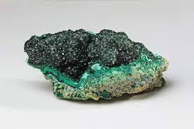
Malachite Overview and Geology
Malachite (Cu₂CO₃(OH)₂) is a copper carbonate hydroxide mineral that forms exclusively in the oxidation zone of copper ore deposits — the near-surface zone where copper sulfide minerals interact with oxygen, water, and carbon dioxide. If you understand that one sentence, you understand where to look for malachite: anywhere copper deposits have been exposed to surface weathering. In the United States, that means the arid Southwest, where hundreds of copper mines and prospects have operated since the 1850s.
The formation process goes like this. Deep underground, copper exists primarily as sulfide minerals — chalcopyrite (CuFeS₂), chalcocite (Cu₂S), and bornite (Cu₅FeS₄). When erosion, faulting, or mining exposes these sulfides to the atmosphere, they oxidize. Rainwater carrying dissolved CO₂ (forming weak carbonic acid) reacts with the copper to produce a suite of secondary copper minerals: malachite (green), azurite (blue), chrysocolla (blue-green), cuprite (red), and native copper. Malachite is the most stable of these under surface conditions, which is why it is the most common secondary copper mineral.
The banded green pattern that makes malachite so visually striking comes from successive layers of precipitation. Each band represents a pulse of mineral-bearing groundwater depositing copper carbonate. The botryoidal (grape-like) growth habit is typical — malachite often coats fracture surfaces and cavity walls with rounded, bubbly masses that reveal banding on cross-section.
One important safety note before we get to locations: malachite contains copper, and copper minerals produce toxic dust when broken or ground. Always wear a dust mask when hammering copper-bearing rock. Wash your hands after handling specimens. Do not eat or drink while collecting at copper mine sites. Some abandoned mine sites may also have arsenic contamination in the soil — check site history before spending extended time at any old mine.
Top US Locations for Malachite
1. Morenci / Clifton Area, Arizona (Greenlee County)
GPS: 33.0880° N, 109.3300° W (BLM land surrounding Morenci — NOT inside the active mine)
Land Status: The Morenci Mine is an active open-pit copper operation owned by Freeport-McMoRan — absolutely no trespassing. BLM land surrounding the mine and in adjacent drainages is open to casual mineral collecting. Some areas are covered by mining claims — check claim status with BLM.
Vehicle: High-clearance 4WD recommended. Desert roads are rough and poorly maintained.
Morenci is the largest copper mine in North America, and the surrounding landscape is saturated with copper mineralization. The Precambrian and Paleozoic host rocks have been intruded by Laramide-age porphyry copper systems (roughly 55-65 million years ago), and the resulting oxidation zone extends well beyond the mine boundaries. On BLM land in the canyons and hillsides around Morenci and Clifton, you can find malachite crusts, botryoidal masses, and staining on exposed rock surfaces.
The malachite here often occurs with azurite, chrysocolla, and turquoise. Specimens range from thin crusts and staining (common) to solid botryoidal masses an inch or more thick (uncommon but findable). Look for green staining on rock outcrops — that is your prospecting indicator. Follow the green to find concentrated malachite deposits. The best material comes from old prospect pits and small workings on BLM land, not from the active mine.
2. Bisbee, Arizona (Cochise County)
GPS: 31.4350° N, 109.9280° W (Bisbee town area — surrounding BLM hills)
Land Status: Historic mines are closed. Some mine dumps are on private mining claims — verify before collecting. BLM land in the Mule Mountains surrounding Bisbee is accessible. Some private land is open to collecting with permission.
Vehicle: Standard 2WD to Bisbee town. High-clearance 4WD for back roads to outlying prospects.
Bisbee is one of the most famous mineral collecting localities in the world. The Bisbee copper district operated from the 1880s through 1975 and produced world-class malachite-azurite specimens that are in every major natural history museum on the planet. The mines are closed, and the best museum-quality material was extracted decades ago, but smaller collectible specimens can still be found on BLM land in the surrounding Mule Mountains.
The geology is a Laramide porphyry copper system hosted in Paleozoic limestone. The carbonate host rock is what made Bisbee's malachite and azurite so exceptional — the limestone provided abundant CO₂ for carbonate mineral formation. Look for malachite in fractures and solution cavities in the limestone on hillsides outside the old mine areas. Old prospect pits dotting the hillsides are worth checking. Be aware that some dumps are on active claims — look for claim markers (posts or cairns).
3. Globe-Miami District, Arizona (Gila County)
GPS: 33.3940° N, 110.7860° W (general Globe area)
Land Status: Mix of active mines (restricted), BLM land, and Tonto National Forest. Some old prospects on public land are accessible. Verify claim status before collecting.
Vehicle: High-clearance 4WD for back-country access roads.
The Globe-Miami copper district sits on the Apache Trail east of Phoenix and has been mining copper since the 1870s. The geology is similar to Morenci and Bisbee — Laramide porphyry copper systems with extensive oxidation zones. The Inspiration and Miami mines are restricted, but BLM land and National Forest in the surrounding mountains host old prospects where malachite, azurite, and chrysocolla occur in fractures and on mine dump material.
The Sleeping Beauty Mine area, better known for turquoise, also produces malachite. Copper Basin and adjacent drainages on Tonto National Forest land have old prospect pits worth investigating. As always, check for active claims before spending time at any site.
4. Tintic Mining District, Utah (Juab County)
GPS: 39.9500° N, 112.1100° W (Eureka/Tintic area)
Land Status: Mix of private mining claims, BLM land, and Uinta National Forest. The Tintic district is heavily claimed — many dumps are on private property. Some BLM parcels between claims are accessible. Check claim status with BLM Salt Lake Field Office.
Vehicle: High-clearance 2WD to most sites. 4WD for some back roads.
The Tintic district near Eureka, Utah, was one of the major metal-producing districts in the western US from the 1870s through the mid-20th century. The mines produced copper, silver, lead, zinc, and gold from replacement deposits in Paleozoic carbonates. The oxidation zone produced malachite, azurite, smithsonite, and cerussite. Malachite occurs on old mine dumps and in prospect pits throughout the district.
The challenge at Tintic is claim status — much of the district is covered by private mining claims, even if no active mining is occurring. Verify ownership before collecting. The BLM Salt Lake Field Office maintains claim records. Some claim holders allow collecting with permission.
5. Santa Rita / Silver City, New Mexico (Grant County)
GPS: 32.7700° N, 108.2700° W (BLM land near Santa Rita — NOT inside Chino Mine)
Land Status: The Chino Mine (Santa Rita open pit) is an active operation — no access. BLM land in the surrounding Silver City district hosts old prospects and small workings where collecting is permitted on unclaimed ground.
Vehicle: High-clearance 4WD for back roads. Standard 2WD to Silver City and main highways.
The Santa Rita copper deposit is one of the oldest continuously mined areas in the American West — copper mining here predates the Spanish colonial period. The geology is a Laramide porphyry copper system similar to the Arizona deposits. The oxidation zone extends into the surrounding mountains, and old prospects on BLM and Gila National Forest land produce malachite with azurite. The Kneeling Nun area and surrounding drainages have accessible prospects. Check with the BLM Las Cruces District Office for current claim maps and access information.
6. Ducktown / Copper Basin, Tennessee (Polk County)
GPS: 35.0380° N, 84.3790° W (Ducktown area)
Land Status: Historic copper mining district. Some areas are EPA Superfund sites with restricted access due to environmental contamination. The Ducktown Basin Museum provides historical context. Surrounding areas outside the Superfund zone may permit surface collecting — verify access before visiting.
Vehicle: Standard 2WD.
The Copper Basin near Ducktown is the only major copper district in the southeastern United States. Mining here ran from the 1840s through 1987. The deposits are massive sulfide bodies in Precambrian metamorphic rocks — different geology from the western porphyry copper systems but producing the same secondary minerals in the oxidation zone. Malachite, azurite, and native copper occur in old prospects and on mine dumps in areas not affected by the Superfund remediation.
Be careful here. The Superfund cleanup addressed severe acid mine drainage and soil contamination from sulfuric acid production. Some areas are posted and restricted. The surrounding hillsides outside the core contamination zone have small prospects where malachite can be found. The Ocoee River gorge downstream also exposes copper-bearing metamorphic rocks.
7. Keweenaw Peninsula, Michigan (Keweenaw & Houghton Counties)
GPS: 47.2800° N, 88.3800° W (general Keweenaw Peninsula area)
Land Status: Mix of private land, state forest, and Keweenaw National Historical Park (no collecting in NHP areas). Some old mine dumps are on private land — get permission. State forest land permits casual surface collecting.
Vehicle: Standard 2WD to most sites. Some back roads require higher clearance.
The Keweenaw Peninsula is famous for native copper — massive chunks of pure copper metal that occur in Precambrian basalt flows. Where this native copper has been exposed to weathering, malachite forms as a secondary coating. Malachite on the Keweenaw tends to occur as thin crusts and staining on native copper and in the basalt host rock. It is rarely the thick botryoidal masses found in Arizona, but the association with native copper makes these specimens interesting.
Old mine dumps (with landowner permission) and stream gravels on state forest land produce copper specimens with malachite coatings. The stamp sands (processed mine tailings) along the Lake Superior shoreline near Gay and other locations contain small copper pieces, some with malachite.
Malachite Specimen Types
| Habit/Form | Description | Typical Locations | Collector Value |
|---|---|---|---|
| Botryoidal masses | Rounded, grape-like growths; banded internally | AZ (Bisbee, Morenci), NM | $10–$500+ depending on size and banding |
| Stalactitic | Elongated, icicle-like formations in cavities | AZ, UT (Tintic) | $25–$300+ for intact stalactites |
| Malachite-azurite | Green malachite with blue azurite; often azurite pseudomorphed to malachite | AZ (Bisbee, Morenci), NM | $15–$1,000+ for fine blue-green specimens |
| Malachite on copper | Green coating on native copper | MI (Keweenaw), AZ | $5–$100 depending on copper specimen quality |
| Fibrous/silky malachite | Radiating fibrous crystals with silky luster | AZ, TN (Ducktown) | $20–$200 for well-developed fibrous specimens |
| Malachite staining/crust | Thin green film on rock surfaces | All copper districts | Minimal collectible value but useful as indicator |
Field Identification: Malachite vs. Look-Alikes
| Property | Malachite | Chrysocolla | Brochantite | Variscite |
|---|---|---|---|---|
| Color | Green (banded light to dark) | Blue-green to cyan | Dark emerald green | Apple green to teal |
| Hardness (Mohs) | 3.5–4 | 2–4 (often very soft) | 3.5–4 | 3.5–4.5 |
| Streak | Green | White to pale blue-green | Pale green | White |
| Acid Reaction | Fizzes in dilute HCl (carbonate) | No fizz (silicate) | Dissolves but no fizz (sulfate) | No fizz (phosphate) |
| Banding | Characteristic banded pattern | Usually uniform color | No banding | No banding |
| Luster | Silky to vitreous | Waxy to dull | Vitreous | Waxy |
The most common field confusion is malachite vs. chrysocolla. Both are green copper minerals that occur together in oxidation zones. The streak test is the fastest distinction: malachite has a green streak, chrysocolla has a white to pale blue-green streak. The acid test confirms — malachite fizzes in dilute hydrochloric acid because it is a carbonate mineral; chrysocolla does not fizz because it is a hydrous copper silicate. If you do not carry acid, the banding test works: malachite almost always shows distinct banding on broken or cut surfaces, while chrysocolla is typically uniform in color.
Brochantite (a copper sulfate) can look very similar to malachite in the field but is rarer. It does not fizz in acid. Variscite (an aluminum phosphate, not a copper mineral at all) occurs in some of the same western states and has a similar green color, but it has a white streak and does not react to acid.
Tools for Malachite Collecting
- Rock hammer (2–3 lb) and cold chisels: For extracting malachite crusts from host rock. Strike the host rock adjacent to the specimen, not the malachite itself — malachite is soft (3.5–4) and damage-prone.
- Dust mask (N95 or better): Non-negotiable at copper mine sites. Copper mineral dust is toxic when inhaled. Silica dust from the host rock adds a second respiratory hazard.
- Safety glasses: Flying rock fragments from hammering.
- Padding material (newspaper, bubble wrap, cloth): Malachite scratches easily. Every specimen should be wrapped individually before going in a bucket or bag. Do not let specimens contact each other.
- Dilute HCl (10% solution) or white vinegar: For the acid fizz test to distinguish malachite from chrysocolla and other green minerals.
- Streak plate (unglazed porcelain): For testing streak color. The back of a ceramic tile from a hardware store works.
- GPS device or smartphone with offline maps: Critical for navigating BLM land boundaries and claim locations in remote desert terrain. Cell service is unreliable at most Arizona copper districts.
- Hand lens (10x): For examining crystal habit and distinguishing fibrous malachite from other green minerals.
Legal Considerations
Active mines: Never enter an active mining operation without written authorization. Morenci, Chino (Santa Rita), and other operating copper mines have security, and trespassing charges are enforced. The minerals inside belong to the mine operator.
Mining claims: Even inactive claims are private property. Look for claim markers — posts or rock cairns at corners, claim notices on trees or posts. When in doubt, check BLM claim records (available online through LR2000 or at local BLM offices) before collecting.
BLM land (unclaimed): Casual collecting of minerals for personal use is permitted on unclaimed BLM land. Reasonable quantities, hand tools only, no commercial sale.
National Forest: Personal-use mineral collecting generally permitted on unclaimed land. Check with the local Ranger District.
Superfund sites: Some old copper mine areas (Ducktown TN, parts of Butte MT, some Bisbee AZ locations) have restricted access due to environmental contamination. Respect closures — the contamination is real.
Safety at old mines: Never enter underground mine workings. Open shafts, unstable tunnels, toxic gases (including oxygen-depleted air), and collapse hazards kill people every year. Collect from surface exposures and dump material only.
Explore the Interactive Malachite Map
Use our interactive malachite location map to find collecting sites with GPS coordinates, land status, claim boundaries, and access information across the western United States.