
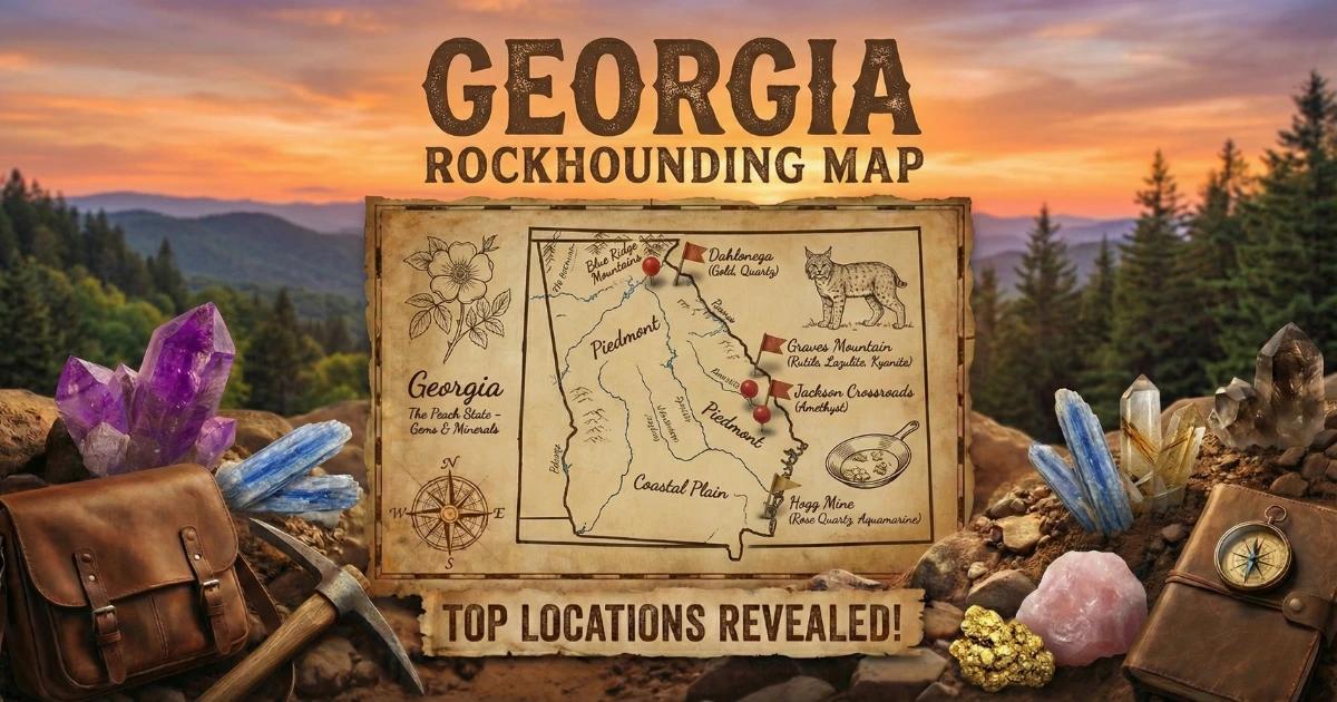
Georgia's Geology and Geode Potential
Georgia is split into five geological provinces, but only two matter for crystal and geode collecting. The Coastal Plain — covering the southern half of the state — is underlain by young, unconsolidated sands, clays, and limestones that produce no geodes. The Piedmont and Blue Ridge provinces in the northern half are built on Precambrian to Paleozoic metamorphic and igneous rock: gneiss, schist, quartzite, granite, and metamorphosed volcanic sequences.
True sedimentary geodes — the hollow limestone nodules common in the Midwest — do not occur in Georgia. The state lacks the Mississippian carbonate shelf deposits that produce Keokuk-style geodes. What Georgia does produce are crystal-lined pockets in altered volcanic rock, quartz vugs in granite and pegmatite, and occasional chalcedony nodules in creek gravel. The experience of cracking open a crystal-lined pocket at Graves Mountain or pulling a vug-bearing quartz piece from a Piedmont creek is functionally identical to geode hunting, even if the geological classification differs.
Top Collecting Sites
1. Graves Mountain (Lincoln County)
GPS: 33.73°N, 82.52°W
Land status: Private — periodic open-house collecting events (typically spring and fall)
Vehicle: 2WD
Graves Mountain is Georgia's most important mineral locality and one of the best-known collecting sites in the southeastern United States. The mountain is an exposure of metamorphosed volcanic rock (pyrophyllite-bearing altered tuff) that hosts an unusual mineral assemblage. The property is privately owned but opens to public collecting during organized events, usually scheduled in spring and fall. Local mineral clubs and the property managers coordinate event dates — check with the Georgia Mineral Society or the Columbia Gem and Mineral Society for schedules.
The target minerals occur in pockets and seams within the altered rock. Crystal-lined cavities function like geodes — you break into them and find well-formed crystals inside. The digging is physical: you work the exposed rock faces with hammers, chisels, and pry bars, splitting along natural fracture planes to expose fresh pockets. The rock is relatively soft (pyrophyllite is a hydrous aluminum silicate with a Mohs hardness of about 1.5 to 2), so hand tools are effective.
Events draw large crowds. Arrive early, stake out a working area, and bring all your own tools and water. There is no shade on the exposed quarry faces.
2. Elberton Area Creeks (Elbert County — Granite Capital)
GPS (general area): 34.11°N, 82.87°W
Land status: Public waterways; private land adjacent
Vehicle: 2WD
Elberton sits on one of the largest continuous granite bodies in the eastern US — the Elberton batholith. This massive granitic intrusion produces abundant quartz veins, and where those veins intersect fractures and weathering surfaces, they create vugs lined with clear to smoky quartz crystals. Creek gravel in the Broad River, Savannah River tributaries, and smaller drainages around Elberton contains vein quartz pieces that occasionally have hollow, crystal-lined interiors.
The collecting method is simple creek walking. Work gravel bars at low water, scanning for white quartz pieces that show crystal faces, banding, or feel light for their size. Most vein quartz is solid and featureless, but one in twenty or thirty pieces may have a vug or pocket worth keeping. Late summer and early fall provide the best water levels.
3. Dahlonega Area (Lumpkin County — Blue Ridge Gold Belt)
GPS (general area): 34.53°N, 83.98°W
Land status: Chattahoochee National Forest (personal collecting permitted) and private
Vehicle: 2WD for main roads; AWD for forest service roads
The Dahlonega area was the site of America's first major gold rush in 1828. The gold occurs in quartz veins cutting through metamorphic rock — the same veins that produce crystal-lined pockets. Creek gravel in the Chestatee River, Yahoola Creek, and Etowah River headwaters contains vein quartz with occasional vugs, druzy quartz faces, and crystal pockets. You may also find small amounts of placer gold, pyrite, and garnet.
Chattahoochee National Forest covers much of the mountainous terrain around Dahlonega. The Forest Service permits personal mineral collecting with hand tools. The Consolidated Gold Mine in Dahlonega offers underground mine tours and gemstone panning for a fee.
4. Stonewall Creek / South River Area (DeKalb / Rockdale Counties)
GPS (general area): 33.68°N, 84.12°W
Land status: Public waterways within metro Atlanta
Vehicle: 2WD
Several creeks in the eastern Atlanta metro area expose Piedmont gneiss and schist with quartz veining. The gravel in Stonewall Creek, South River, and Yellow River tributaries contains small quartz vugs and crystal-bearing pieces. These are not large or museum-quality specimens, but they offer beginning collectors an introduction to creek hunting without a long drive. Arabia Mountain, a granite monadnock in DeKalb County managed as a national heritage area, shows exposed bedrock with visible quartz veining — though collecting is prohibited within the heritage area boundaries.
5. Washington-Wilkes Area (Wilkes County)
GPS (general area): 33.74°N, 82.74°W
Land status: Public waterways; surrounding land mostly private
Vehicle: 2WD
Wilkes County sits on the eastern edge of the Piedmont with extensive quartz veining in the underlying gneiss and granite. Creeks draining toward the Savannah River — including Fishing Creek and Little River — carry quartz-rich gravel that includes occasional vug-bearing specimens and agate-like chalcedony nodules. The area is rural, and most surrounding land is privately owned. Collect from the stream channels and ask permission before crossing property lines.
Specimens You Can Expect
| Mineral / Specimen | Location | Typical Size | Notes |
|---|---|---|---|
| Rutile | Graves Mountain | 0.5–3 inches | Metallic black prismatic crystals; twinned "knee" shapes are prized |
| Lazulite | Graves Mountain | 0.5–2 inches | Deep blue crystals in pyrophyllite matrix |
| Kyanite | Graves Mountain | 1–4 inches | Blue bladed crystals; common at this locality |
| Iridescent hematite | Graves Mountain | 1–3 inches | Thin plates with rainbow iridescence |
| Quartz crystal vugs | Piedmont creeks statewide | 1–4 inches | Clear to smoky quartz lining vein cavities |
| Pyrite | Blue Ridge gold belt creeks | 0.25–1 inch | Cubic crystals; common in quartz vein material |
| Garnet (almandine) | Blue Ridge and Piedmont creeks | 0.25–0.75 inch | Dark red dodecahedral crystals in metamorphic gravel |
Field Identification Tips
At Graves Mountain, the target minerals are embedded in soft, pale pyrophyllite matrix. Rutile crystals are jet-black, metallic, and hard — they scratch the surrounding rock easily. Lazulite is a distinctive deep blue that does not fade when wet. Kyanite blades are pale to dark blue and have a unique property: hardness varies depending on the direction you scratch (harder across the blade, softer along it).
In Piedmont creeks, most of the gravel is vein quartz. To find the pieces worth keeping, look for crystal terminations — flat faces with sharp edges rather than the rounded, featureless surfaces of tumbled quartz. Pick up pieces that feel lighter than expected (possible hollow interior) or show any external texture change — rougher patches on an otherwise smooth cobble may indicate a vug just beneath the surface.
Tools and Gear
- Rock hammer (3 lb) and cold chisels: Essential for Graves Mountain — you are breaking rock
- Pry bar (18–24 inches): For leveraging apart rock layers at Graves Mountain
- Safety glasses: Non-negotiable when hammering metamorphic rock
- 5-gallon bucket: For specimens and creek collecting
- Newspaper or bubble wrap: For wrapping crystal specimens
- Wading boots or old sneakers: For creek collecting
- Water (2+ gallons per person): Graves Mountain has no shade and no water source
- Sunscreen, hat, long pants: Georgia sun and underbrush ticks
Legal Notes and Access
- Graves Mountain: Collecting is only permitted during scheduled open-house events. Do not trespass outside event dates. The property is actively monitored.
- Chattahoochee National Forest: Personal mineral collecting with hand tools is permitted. No mechanized equipment. Respect wilderness area boundaries where all collecting is prohibited.
- Public waterways: Georgia law allows wading and collecting in navigable streams below the ordinary high-water mark. Do not climb banks onto private land without permission.
- Arabia Mountain National Heritage Area: Collecting rocks and minerals is prohibited within the heritage area.
- Best season: Year-round. Spring and fall are most comfortable for fieldwork. Graves Mountain events are typically in April and October.
See our Georgia rockhounding map for GPS coordinates and more locations.