
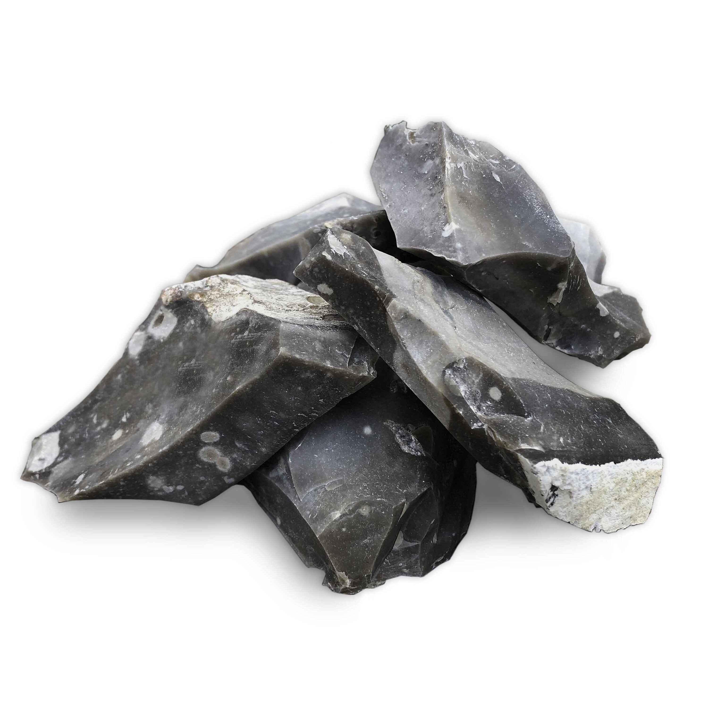
Flint and Chert Overview and Geology
Flint and chert are the same mineral — microcrystalline quartz (SiO₂) — formed in sedimentary environments. The naming convention is mostly historical and regional. "Flint" traditionally refers to dark-colored nodular material found in chalk and limestone formations, particularly in Europe and eastern North America. "Chert" is the broader geological term encompassing all varieties of sedimentary microcrystalline silica, including bedded deposits. In practice, most American geologists use "chert" as the default term and "flint" when referring to high-quality, dark, nodular material specifically suited for knapping.
The formation process starts with biological silica. Sponge spicules, radiolarian tests, and diatom frustules — all made of amorphous silica (opal-A) — accumulate in marine sediments. After burial, the biogenic silica dissolves and reprecipitates as microcrystalline quartz, often concentrating into nodules within limestone and chalk. The nodules grow by replacing the surrounding carbonate, molecule by molecule, which is why flint nodules often preserve the outlines of fossils from the original limestone. Some chert forms as bedded deposits — continuous layers of silica precipitated directly on the seafloor, typically in deep-water settings.
The conchoidal fracture of flint is what made it the foundation of human tool technology for over two million years. When struck correctly, flint breaks with smooth, curved fracture surfaces and razor-sharp edges — exactly what you need for cutting tools, scrapers, and projectile points. The Mohs hardness of 7 means it is harder than steel, so a flint edge holds up against most materials. This same conchoidal fracture is what makes flint specimens visually appealing to modern collectors — fresh fracture surfaces have a waxy luster and smooth curves that catch light.
Top US Locations for Flint and Chert
1. Flint Ridge, Ohio (Licking & Muskingum Counties)
GPS: 40.0000° N, 82.1350° W (Flint Ridge State Memorial)
Land Status: Flint Ridge State Memorial (Ohio History Connection). Collecting is permitted within the designated collecting areas of the park. The memorial includes a museum and interpretive trails showing the ancient quarry pits. Some surrounding private land may have flint exposures — get landowner permission.
Vehicle: Standard 2WD. Paved roads to the memorial.
Flint Ridge is the single most significant flint deposit in eastern North America, both geologically and archaeologically. The flint occurs in the Vanport Limestone Member of the Pennsylvanian-age Allegheny Formation — a Carboniferous carbonate unit roughly 310 million years old. The silica replacement was extensive here, producing massive flint beds up to 10 feet thick that extend for approximately 8 miles along the ridge.
What makes Flint Ridge material exceptional is the color range. Unlike the drab gray or black flint from most locations, Flint Ridge produces red, blue, gray, cream, pink, green, and multicolored banded varieties. Some pieces show four or five colors in a single specimen. The Native American peoples of the region recognized this quality — Flint Ridge was one of the most important lithic quarry sites on the continent, with material traded across thousands of miles. Quarry pits dating back at least 12,000 years are visible across the ridge.
Collecting at the state memorial is permitted in designated areas. The flint occurs as nodules weathering out of limestone, as chunks in the soil, and as debris from ancient and historic quarrying operations. Bring a bucket and gloves — fresh breaks on Flint Ridge material are sharp enough to cut skin.
2. Edwards Plateau, Texas (Central Texas — Multiple Counties)
GPS: 30.6700° N, 98.3900° W (general Hill Country area — Llano County)
Land Status: Mostly private ranch land. Collecting on public road rights-of-way, state highway road cuts, and creek beds on public land is generally permitted. Pedernales Falls State Park allows limited surface collecting — check current park rules. Alibates Flint Quarries National Monument near Amarillo — no collecting.
Vehicle: Standard 2WD for highway road cuts and creek access points. High-clearance 4WD for ranch roads (with permission).
The Edwards Plateau is underlain by Cretaceous-age limestone (roughly 100 million years old) of the Edwards and Georgetown Formations. These formations contain massive beds and nodules of chert in white, gray, tan, brown, and occasionally reddish colors. The chert is exposed in every road cut, creek bed, and hillside across the Texas Hill Country from Austin to Junction and beyond.
The material quality varies. Some Edwards chert is coarse-grained and rough — fine for casual collecting but not great for knapping. The best-quality material is fine-grained, semi-translucent, and fractures with clean conchoidal breaks. Creek beds in the Hill Country are the easiest collecting — water transport rounds and polishes pieces, and you can evaluate quality by examining the fresh surfaces of naturally broken pieces. Georgetown and surrounding communities have accessible creek beds with abundant chert.
Alibates Flint Quarries National Monument near Amarillo, in the Texas Panhandle, preserves a spectacular multicolored flint deposit in the Alibates Formation (Permian age). The reds, purples, whites, and maroons of Alibates flint are unmistakable. Collecting is prohibited at the monument, but the National Park Service offers guided interpretive hikes to the ancient quarry sites — worth the trip to see this material in context.
3. Flint Hills, Kansas (East-Central Kansas — Chase, Lyon, Butler Counties)
GPS: 38.3400° N, 96.5600° W (general Flint Hills region — Chase County)
Land Status: Mostly private ranch land (tallgrass prairie). Stream beds crossing public roads are accessible. Tallgrass Prairie National Preserve allows surface observation but not collecting. Public road right-of-way collecting of loose material is generally permitted.
Vehicle: Standard 2WD for main roads and stream crossings. Some back roads are unimproved.
The Flint Hills are named for the abundant chert that erodes from Permian-age limestone formations (roughly 250-280 million years old). The chert occurs as nodules and thin beds within the Florence Limestone, the Fort Riley Limestone, and other Permian carbonate units. As the limestone weathers, the more-resistant chert remains — the hills are literally held up by the material.
Collecting here is primarily from stream gravels. The Smoky Hill River, the Cottonwood River, and dozens of smaller streams cutting through the Flint Hills carry rounded chert cobbles in their gravel bars. These stream-tumbled pieces are easy to evaluate — you can see the color, grain, and fracture quality without breaking them. Colors are typically gray, tan, brown, and occasionally dark brown to black. The material is good-quality chert, suitable for knapping and general collecting.
Much of the Flint Hills is privately owned tallgrass prairie ranch land. Do not cross fences onto private property without permission. Stream beds below ordinary high-water mark on public roads and bridges are your best legal access points.
4. Dover / Cumberland Plateau, Tennessee (Stewart County and Region)
GPS: 36.4900° N, 87.8400° W (Dover area — Land Between the Lakes)
Land Status: Land Between the Lakes National Recreation Area (USDA Forest Service) — check current collecting regulations. Surrounding BLM and state-managed areas may permit surface collecting. Private land requires permission.
Vehicle: Standard 2WD for main roads.
The Cumberland Plateau and Highland Rim regions of Tennessee expose Mississippian-age limestone (roughly 320-340 million years old) containing abundant gray, black, and brown chert. The Dover Chert, a named archaeological material type, comes from the Fort Payne Formation in the western Highland Rim. This material was heavily used by prehistoric Native Americans and is found across the Southeast in archaeological contexts.
For modern collectors, stream gravels in the rivers draining the Highland Rim — the Tennessee River, Cumberland River, and their tributaries — produce rounded chert cobbles. Road cuts through the Fort Payne Formation expose chert nodules in the limestone. The best material is fine-grained, dark gray to black, and fractures cleanly. Land Between the Lakes National Recreation Area straddles the Tennessee-Kentucky border and has accessible stream gravels.
5. Coastal Plain, Georgia (Multiple Counties)
GPS: 32.8600° N, 83.6200° W (general central Georgia — Bibb County area)
Land Status: Mostly private land. Creek beds and river gravel bars on public access points are generally available. State-managed wildlife management areas may permit surface collecting — check specific WMA regulations.
Vehicle: Standard 2WD for most creek access points.
The Coastal Plain of Georgia produces chert in river and creek gravels derived from the erosion of Cretaceous and Paleogene limestone formations. The material includes gray, brown, and cream-colored chert, plus "Coastal Plain agate" — a banded variety that grades between chert and agate. The Ocmulgee, Flint (yes, named for the material), and Oconee River systems carry chert cobbles in their gravel bars. After high-water events, fresh material is exposed on gravel bars.
The quality ranges widely. Some pieces are coarse and dull; others are fine-grained with waxy luster and beautiful banding. Sort through gravel bars methodically — the best pieces stand out when wet. A spray bottle speeds up the evaluation process.
6. Upper Mississippi Valley (Iowa, Illinois, Missouri)
GPS: 40.7500° N, 91.1200° W (general Keokuk, Iowa area — Lee County)
Land Status: River gravel bars on public access points. Some state parks and conservation areas permit surface collecting. Private land — get permission.
Vehicle: Standard 2WD.
The Upper Mississippi Valley exposes Mississippian and Ordovician carbonates containing extensive chert. The Keokuk Formation and Burlington Limestone in southeastern Iowa and western Illinois produce gray, white, and brown chert nodules, some containing drusy quartz-lined vugs (geodes). The Mississippi River and its tributaries carry chert cobbles derived from these formations. Stream gravel collecting is productive along the Des Moines, Illinois, and Missouri Rivers.
Burlington chert, specifically, is one of the highest-quality knapping materials in the Midwest — fine-grained, homogeneous, and white to light gray. Prehistoric peoples traded Burlington chert across half the continent. You can find it in stream gravels in Pike County, Missouri, and Adams and Hancock Counties, Illinois.
Flint and Chert Specimen Types
| Named Type | Color Range | Source Location | Formation / Age | Collector Notes |
|---|---|---|---|---|
| Flint Ridge flint | Red, blue, gray, cream, multicolored banded | Licking County, OH | Vanport Limestone / Pennsylvanian | Best color variety of any US flint; state gemstone of Ohio |
| Alibates flint | Red, purple, white, maroon banded | Potter County, TX (Panhandle) | Alibates Fm. / Permian | No collecting at monument — museum specimens only |
| Edwards Plateau chert | White, gray, tan, brown | Central TX (multiple counties) | Edwards Limestone / Cretaceous | Most abundant Texas chert; variable quality |
| Burlington chert | White to light gray | SE Iowa, W Illinois, N Missouri | Burlington Limestone / Mississippian | Premium knapping material; widely traded prehistorically |
| Dover chert | Dark gray to black | W Tennessee, S Kentucky | Fort Payne Fm. / Mississippian | Fine-grained; heavy prehistoric use |
| Flint Hills chert | Gray, tan, brown | E-central Kansas | Florence & Fort Riley Ls. / Permian | Abundant in stream gravels; moderate quality |
| Coastal Plain chert/agate | Gray, brown, banded | GA, AL, MS, SC | Mixed Cretaceous-Paleogene sources | Banded varieties grade into agate; collected from rivers |
Field Identification: Flint/Chert vs. Look-Alikes
| Property | Flint/Chert | Quartzite | Jasper | Limestone |
|---|---|---|---|---|
| Hardness (Mohs) | 7 | 7 | 6.5–7 | 3 (calcite) |
| Fracture | Conchoidal (smooth curves, sharp edges) | Granular to conchoidal (sugary texture on break) | Conchoidal (similar to chert) | Irregular to subconchoidal |
| Luster | Waxy to dull | Granular, sparkly (individual quartz grains visible) | Waxy to dull | Dull to earthy |
| Transparency | Opaque to slightly translucent on thin edges | Opaque | Opaque | Opaque |
| Acid Test | No reaction | No reaction | No reaction | Fizzes in dilute HCl |
| Sound When Struck | High-pitched ring | Dull thud | Ring (similar to chert) | Dull thud |
The most common field confusion is chert vs. quartzite. Both are hard, both scratch glass, and both can look similar in color. The key difference is fracture surface texture. Break a piece and look closely: chert breaks with smooth, glassy conchoidal surfaces — the break looks like thick glass. Quartzite breaks with a granular or sugary texture — you can see individual sand grains on the fracture surface, even if you need a hand lens. Quartzite is metamorphosed sandstone and retains the granular structure of the original sand. Chert is precipitated silica and has no granular structure.
Chert vs. jasper is a distinction geologists argue about. Both are microcrystalline quartz. The informal convention: jasper is opaque and often red (colored by iron oxide), while chert is the broader category. In the field, it does not matter — they form in similar ways and have the same properties.
Chert nodules in limestone are sometimes confused with the limestone itself. The acid test is definitive: limestone fizzes in dilute HCl or vinegar; chert does not. When you find a nodule in a road cut, drip some vinegar on both the nodule and the surrounding rock — the limestone fizzes, the chert stays quiet.
Tools for Flint and Chert Collecting
- Rock hammer (geological pick): For extracting nodules from limestone matrix in road cuts and quarry walls. The pointed end of a geological pick works well for prying nodules loose.
- Heavy leather gloves: This is not optional. Freshly broken flint produces edges that are sharp enough to cut through standard work gloves. Heavy leather or cut-resistant gloves are the minimum. Native Americans used flint to make surgical cutting tools — treat fresh breaks with the same respect.
- Safety glasses: Flint fragments fly when struck. A chip in the eye is a real risk. Wear ANSI-rated safety glasses, not regular sunglasses.
- Spray bottle: Wetting surfaces reveals color, banding, and quality that are invisible on dry, dusty surfaces. Essential for evaluating material in stream gravels.
- Bucket or sturdy bag: Flint is dense (SG ~2.6) and adds up in weight quickly. A 5-gallon bucket of chert cobbles will weigh 40+ pounds.
- Hand lens (10x): For evaluating grain size and internal structure. Fine-grained, homogeneous material is the highest quality.
- Trim saw (at home): A small diamond trim saw reveals the internal color and banding of nodules. Many collectors slab their finds to evaluate quality and reveal hidden patterns.
Legal Considerations
State parks and memorials: Flint Ridge State Memorial (OH) permits collecting in designated areas. Pedernales Falls State Park (TX) has varying rules — check current regulations. Alibates Flint Quarries National Monument — zero collecting.
Archaeological sites: Do not collect or disturb artifacts. Arrowheads, flaked tools, and debitage (flaking debris) at archaeological sites are protected under the Archaeological Resources Protection Act (ARPA) on federal and tribal land, and under state laws on state land. If you find a worked artifact, leave it in place. Collecting raw, unworked flint/chert material is distinct from collecting artifacts.
Road cuts and rights-of-way: Collecting loose material from state highway road cuts is generally permitted in most states. Do not dig into road cut faces or create safety hazards. Park safely off the roadway.
Creek beds and river gravel: Navigable waterways are generally public below the ordinary high-water mark. Non-navigable streams may have different rules depending on state law. In Texas, navigable streams are public; in some other states, the streambed is owned by adjacent landowners. Know your state's water law.
Private land: Most of the Flint Hills, Edwards Plateau, and Coastal Plain are private land. Get permission before crossing fences. A conversation with the landowner — explaining that you collect rocks, not artifacts — usually goes well.
Explore the Interactive Flint Map
Use our interactive flint location map to find collecting sites with GPS coordinates, land status, and access information. Also check our chert map for additional locations across all 50 states.