
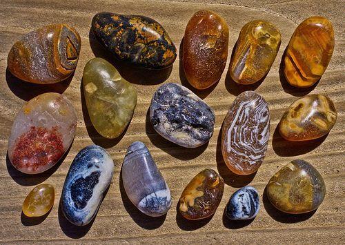
Agate Overview and Geology
Agate is a banded variety of chalcedony — microcrystalline quartz (SiO₂) — that forms in volcanic rock cavities. The banding is the defining characteristic. Each band represents a separate episode of silica deposition from groundwater, and variations in trace elements, temperature, and water chemistry produce the color changes between bands. The process is slow — a single agate may take millions of years to fill its cavity completely.
The typical formation sequence starts with a gas bubble (vesicle) in cooling basalt or rhyolite lava. Long after the lava solidifies, silica-rich groundwater percolates through fractures and begins precipitating chalcedony on the cavity walls. Iron oxides produce reds, oranges, and yellows. Manganese oxides produce blacks and purples. Chromium and nickel create greens. Clear and white bands are relatively pure silica. Some agates never fill completely, leaving a hollow center lined with quartz crystals — these are geodes.
The variety within the agate family is staggering. Fortification agates show angular, fortress-like banding patterns. Plume agates contain feathery inclusions of iron or manganese oxide that look like underwater plants. Moss agates have dendritic (branching) inclusions of chlorite or other minerals. Fire agates contain thin layers of iron oxide (limonite/goethite) over chalcedony that produce iridescent play-of-color through thin-film interference — the same physics that makes soap bubbles shimmer. Thundereggs are agate-filled nodules where the outer shell is rhyolite or perlite.
What makes agate collecting so addictive is that the exterior of an uncut agate gives almost no indication of the interior. A lumpy, rough, gray stone might contain explosive color inside. Every agate is a gamble until you cut it.
Top US Locations for Agates
1. Madras / Priday Beds, Oregon (Jefferson County)
GPS: 44.6330° N, 121.1290° W (Richardson's Rock Ranch area)
Land Status: The Priday Plume Agate beds on BLM land were historically open for collecting but access has become restricted due to surface ownership changes — check current BLM status. Richardson's Rock Ranch is a private fee-dig operation (thundereggs). Some BLM parcels east of Madras remain open for casual collecting.
Vehicle: High-clearance 2WD for most BLM roads. 4WD recommended after rain on clay surfaces.
Central Oregon is the agate capital of the United States, and the Madras area is ground zero. The Priday Plume Agate beds produce world-class plume agates — translucent chalcedony containing feathery plume inclusions in red, orange, and yellow against a clear or bluish base. The material formed in Oligocene-age volcanic ash and tuff deposits (~30 million years old). These agates are among the most sought-after varieties in the world for lapidary work.
Richardson's Rock Ranch, southeast of Madras, is the most accessible site. For a daily fee, you dig thundereggs from a rhyolite ash deposit. The thundereggs range from golf-ball to basketball-sized, and you will not know what is inside until you cut them — some contain solid agate with moss or plume inclusions, others have quartz crystal centers, and some are duds. The ranch provides digging tools and equipment to cut your finds on-site.
The Oregon coast is another productive zone. Agate Beach near Newport (44.6620° N, 124.0660° W) produces water-tumbled agates in the surf line, washed down from Miocene volcanic formations inland. After winter storms, beach collecting is at its best — fresh agates wash up in the high-tide debris line. Scan the wet gravel at the waterline with a low sun angle, looking for translucent stones that glow when backlit.
2. Yellowstone River Valley, Montana (Yellowstone, Treasure & Rosebud Counties)
GPS: 46.0200° N, 107.4500° W (general Yellowstone River gravel bars downstream of Billings)
Land Status: The Yellowstone River is a public navigable waterway. Collecting from gravel bars at public access points (fishing access sites, bridge crossings) is legal. Gravel bars are public below ordinary high-water mark. Banks above high-water mark may be private — do not cross fences.
Vehicle: Standard 2WD to fishing access sites and bridge crossings.
Montana agates are among the most prized in North America. They are translucent to semi-transparent chalcedony with dendritic inclusions of manganese oxide that create landscape-like scenes inside the stone — some look like miniature forests, mountains, or prairie skylines frozen in translucent amber. The source rock is Eocene-age volcanic material from the Absaroka Volcanic Province in the mountains west of Billings. Erosion carries the agates into the Yellowstone River system, where they accumulate in gravel bars.
The classic collecting method: wade or walk gravel bars on the Yellowstone River downstream of Billings, scanning wet gravel for translucent stones. Agates stand out from ordinary river rock when wet because they transmit light — they glow while everything around them stays dull. A spray bottle and a sunny day are your best tools. The best collecting is after spring runoff recedes (late June through October) and fresh gravel bars are exposed.
Do not overlook tributary streams. The Musselshell River, Bighorn River, and smaller creeks also carry agates. Gravel pits in the Yellowstone Valley produce agates too — ask the pit operator for permission to scan the gravel piles.
3. Lake Superior Beaches, Minnesota and Michigan (Multiple Counties)
GPS: 47.0300° N, 91.6700° W (Agate Bay, Two Harbors, Minnesota)
Land Status: Public beaches along Lake Superior. Surface collecting of agates from the beach is legal. State parks along the shore have varying rules — most permit surface beach collecting.
Vehicle: Standard 2WD to all beach access points.
Lake Superior agates are the state gemstone of Minnesota. They formed roughly 1.1 billion years ago in vesicles within the Midcontinent Rift basalt flows — the same volcanic event that created the Lake Superior basin. Subsequent glaciation (most recently the Wisconsin Glaciation, ~10,000 years ago) ripped the agates from their basalt host rock and scattered them across a vast area from northern Minnesota to central Iowa.
The iron-rich chemistry of the Lake Superior region produces agates with strong red, orange, and yellow banding from iron oxide. Classic Lake Superior agates are translucent with fortification-pattern banding in warm tones. Size ranges from pea-sized to rare basketball-sized specimens — most are in the 1-4 inch range.
On the Minnesota shore, productive beaches include Agate Bay (Two Harbors), Burlington Bay, and beaches along the North Shore Drive (Highway 61). In Michigan, the Keweenaw Peninsula beaches and the shores of Isle Royale produce agates. On both shorelines, the best collecting follows storm events that rearrange beach gravel. Walk the wave-washed zone slowly, scanning for the characteristic translucent glow of agate among the dull basalt cobbles.
Gravel pits throughout Minnesota, Wisconsin, and Iowa also produce Lake Superior agates transported south by glaciers. Ask pit operators for access — many are happy to let collectors scan spoil piles.
4. Saddle Mountain / Tonopah, Arizona (Maricopa County)
GPS: 33.3200° N, 113.0600° W (Saddle Mountain BLM area)
Land Status: BLM land. Casual mineral collecting permitted under standard BLM rules (reasonable quantities, hand tools, personal use only).
Vehicle: High-clearance 4WD required. Desert roads are rough, rocky, and sandy. Carry extra water and fuel — no services in the area.
Saddle Mountain is the primary fire agate collecting area in the United States. Fire agate is a rare variety of chalcedony coated with thin layers of iron oxide (limonite and goethite) that produce iridescent play-of-color — flashes of red, orange, gold, green, and occasionally blue-purple. The effect is caused by thin-film interference (the same physics as opal play-of-color, but with iron oxide layers instead of silica spheres).
Fire agates here occur in vesicles and fractures in Tertiary basalt and rhyolite. Collecting requires digging into the volcanic host rock with a rock hammer and chisels to extract the agate nodules. This is not surface collecting — it is hands-and-knees work in hot desert terrain. The fire agate material must be carefully oriented and shaped during lapidary work to reveal the play-of-color, which exists only in the thin iron oxide layers on the surface.
Deer Creek, near Globe (Gila County, 33.3800° N, 110.7900° W), is another productive fire agate location on Tonto National Forest land. Similar desert terrain, similar extraction requirements.
5. Yellowstone Area / Absaroka Range, Wyoming (Park & Hot Springs Counties)
GPS: 44.2800° N, 109.3500° W (general Absaroka foothills east of Yellowstone NP)
Land Status: Mix of Shoshone National Forest, BLM land, and private ranches. Collecting within Yellowstone National Park is prohibited. National Forest and BLM land outside the park permits casual collecting.
Vehicle: High-clearance 4WD for Forest Service and BLM back roads. Seasonal access — many roads close in winter.
The Absaroka Volcanic Province produced massive volumes of volcanic rock during the Eocene (~50 million years ago), and agates formed in vesicles and fractures throughout this terrain. Stream gravels draining the Absaroka Range carry agates into the Bighorn Basin and surrounding lowlands. The material includes banded agate, moss agate, and occasional plume agate. Wyoming moss agate — translucent chalcedony with green chlorite dendrites — is highly valued by lapidary workers and jewelers.
Creek beds and gravel bars on BLM and National Forest land east of Yellowstone are productive. The Greybull River, the Shoshone River, and their tributaries carry agate in their gravels. Spring runoff exposes fresh material each year.
6. Big Bend / Alpine, Texas (Brewster County)
GPS: 30.3600° N, 103.6600° W (Woodward Ranch area, Alpine)
Land Status: Woodward Ranch is a private fee-dig operation. BLM land in the area permits casual collecting. Big Bend National Park — no collecting.
Vehicle: High-clearance 2WD to Woodward Ranch. 4WD for BLM back roads.
Far west Texas produces a variety of agates: banded agate, plume agate, pompom agate (with spherical inclusions), and bouquet agate. The volcanic terrain of the Trans-Pecos region — Tertiary-age rhyolite and basalt — provides the host rock. Woodward Ranch near Alpine is the most famous fee-dig operation. For a daily fee, you drive or walk across the ranch, scanning volcanic terrain for agate nodules. The diversity of material here is exceptional — some areas produce plume agates, others produce banded material, and specific zones have distinct color palettes.
BLM land in Brewster, Presidio, and Jeff Davis Counties also has agate-bearing volcanic exposures. Big Bend National Park contains spectacular geology but no collecting is permitted.
7. Hauser Beds / Blythe Area, California (Riverside & Imperial Counties)
GPS: 33.2400° N, 114.5300° W (Hauser Geode Beds, Imperial County)
Land Status: BLM land. Casual collecting permitted.
Vehicle: High-clearance 4WD required. Remote desert — carry water, fuel, and supplies for self-rescue.
The Hauser Geode Beds in the Chocolate Mountains produce geodes and agate nodules from a Miocene volcanic unit. The geodes — technically a type of agate where the interior remained hollow and filled with crystals rather than solid chalcedony — range from tennis-ball to watermelon-sized. You dig them from the weathered volcanic ash with shovels and rock hammers. The Wiley Well area nearby (33.3500° N, 114.9200° W) also produces geodes and agate on BLM land.
Agate Specimen Types
| Variety | Key Feature | Best Locations | Typical Size | Collector Value |
|---|---|---|---|---|
| Fortification agate | Angular, fortress-like banding pattern | MN/MI (Lake Superior), OR, MT | 1–8 inches | $5–$200 depending on color and pattern |
| Plume agate | Feathery inclusions in translucent chalcedony | OR (Priday beds), TX (Big Bend) | 2–6 inches | $10–$500+ for fine plume specimens |
| Moss agate | Dendritic mineral inclusions (not true moss) | MT, WY, OR | 1–6 inches | $5–$150 depending on scene quality |
| Fire agate | Iridescent play-of-color from iron oxide layers | AZ (Saddle Mountain, Deer Creek) | 0.5–3 inches | $20–$2,000+ for gem-quality fire material |
| Montana agate | Translucent with landscape-like dendritic scenes | MT (Yellowstone River) | 1–4 inches | $5–$300+ for scenic specimens |
| Lake Superior agate | Iron-rich red/orange/yellow banding | MN, MI, WI, IA | 1–6 inches | $2–$200+ for large, well-banded specimens |
| Thunderegg | Agate-filled nodule in volcanic ash | OR (Richardson's Ranch) | 2–12 inches | $5–$100; value in surprise interior |
| Geode | Hollow agate shell with crystal-lined interior | CA (Hauser Beds), IA (Keokuk), IN | 2–10 inches | $3–$75 depending on crystal quality |
Field Identification: Agate vs. Look-Alikes
| Property | Agate | Common Opal | Chalcedony (unbanded) | Chert/Flint |
|---|---|---|---|---|
| Translucency | Translucent to semi-transparent | Translucent to opaque | Translucent | Opaque to slightly translucent |
| Banding | Present — defining characteristic | Absent | Absent (uniform color) | Sometimes present but less regular |
| Hardness | 6.5–7 | 5.5–6.5 | 6.5–7 | 7 |
| Luster | Waxy to vitreous on cut surfaces | Waxy to resinous | Waxy | Waxy to dull |
| Origin | Volcanic cavities (vesicles) | Volcanic — hot spring and weathering deposits | Volcanic cavities (same as agate) | Sedimentary — nodules in limestone |
The wet test is the fastest way to identify agates in the field. Spray a suspected agate with water and hold it toward the sunlight. If light passes through the stone — even faintly — and you can see banding, it is almost certainly agate. Ordinary basalt cobbles and chert stay opaque when wet. Translucency is the single most reliable field indicator.
Common opal can look similar but is softer (5.5-6.5 on Mohs) — it will not scratch a steel file, while agate will. Unbanded chalcedony is essentially agate without the banding — same mineral, different habit. The distinction matters for collectors and lapidary workers but not for field identification. Chert and flint are opaque varieties of the same mineral family and formed in sedimentary rather than volcanic settings.
Tools for Agate Collecting
- Spray bottle: The most important tool in agate hunting. Wetting stones reveals translucency and banding that are invisible on dry surfaces. On gravel bars, a systematic spray-and-scan approach multiplies your find rate.
- Knee pads: Agate hunting on gravel bars means hours on your hands and knees scanning the ground at close range. Quality knee pads prevent the misery of bruised kneecaps on river cobbles.
- Rock hammer and chisels: For fire agate extraction from basalt host rock (Arizona sites). Not needed for gravel-bar collecting.
- Bucket, mesh bag, or sturdy backpack: Agates are dense (SG 2.6) and accumulate weight fast. A 5-gallon bucket of agates weighs 40+ pounds.
- Sunglasses (polarized): Polarized lenses help spot translucent agates in bright sun — they reduce glare from wet gravel surfaces, making translucent stones stand out.
- Hand lens (10x): For examining banding, inclusions, and surface details. Useful for distinguishing moss agate dendrites from actual cracks.
- UV flashlight (shortwave): Some agates fluoresce under UV light. Night collecting on beaches and gravel bars using UV can reveal agates that are invisible by daylight.
- Small trim saw (at home): You will not know what most agates look like inside until you cut them. A small diamond trim saw is the essential home tool for agate collectors.
Legal Considerations
BLM land: Casual collecting of agates for personal use is permitted on BLM land. Reasonable quantities, hand tools only, no commercial collecting without a permit. Most western agate sites are on BLM land.
National Forest: Personal-use mineral collecting generally permitted on unclaimed Forest Service land. Check with the local Ranger District for specific regulations.
Public waterways: Rivers and navigable streams are public below the ordinary high-water mark. Gravel bars are legal collecting ground in most states. Beach collecting on ocean shorelines is legal on public beaches.
National Parks: No collecting. Yellowstone, Big Bend, and all other NPS units prohibit mineral collecting. Do not cross park boundaries with collecting intentions.
Fee-dig operations: Richardson's Rock Ranch (OR), Woodward Ranch (TX), and other fee-dig sites charge a daily fee. You keep what you find. Rules vary — ask about tool restrictions and collecting limits.
Private land: Get permission. Most Montana ranch land along the Yellowstone River is privately owned above the high-water mark. Gravel bars within the river are public, but accessing them by crossing private land requires the landowner's consent.
Explore the Interactive Agate Map
Use our interactive agate location map to find collecting sites near you with GPS coordinates, land status, and access information. Also check our fire agate map and moss agate map for variety-specific locations across the United States.