
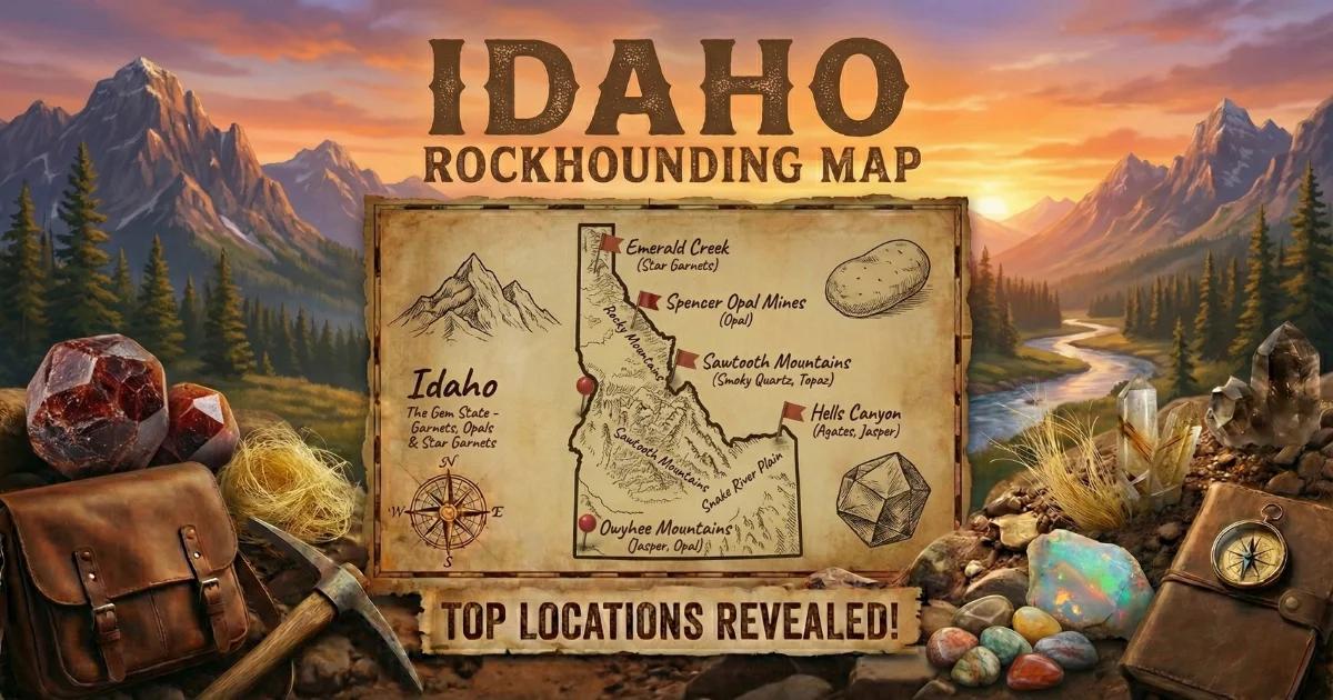

Idaho: The Gem State — And It Earned That Name
Idaho did not get the nickname "The Gem State" by accident. The state sits on a collision zone of geologic provinces — the Idaho Batholith, Columbia River Basalt Group, Basin and Range extension, and remnants of Precambrian Belt Supergroup sediments — and each of those terranes contributed something to the collector. Star garnets that form in only two places on Earth. Volcanic opal in rhyolite flows. Sapphires washed out of deep-seated igneous intrusions. Jasper and agate baked into basalt along the Snake River Plain. Placer gold concentrated by millions of years of mountain erosion. If you collect minerals, cut cabochons, facet gemstones, or pan for gold, Idaho has ground worth working.
What makes Idaho especially accessible is land ownership. The state contains roughly 33.6 million acres of federal land managed by the Bureau of Land Management and the U.S. Forest Service. That is over 60 percent of Idaho's total land area. Most of it is open to casual mineral collecting under federal regulations. You can drive for hours across BLM desert in Owyhee County or hike into the Salmon-Challis National Forest and collect surface specimens without a permit, as long as you stay within the 25-pound-per-day / 250-pound-per-year limit set by BLM policy or the "reasonable amounts" standard used by the Forest Service.
This guide covers the geology that makes Idaho productive, the specific locations where you can collect, what minerals to expect, how to identify them in the field, what tools to bring, and the legal framework that governs collecting on public land.
Geology: Why Idaho Produces What It Produces
Idaho's mineral diversity comes from a layered geologic history spanning nearly two billion years.
Precambrian Belt Supergroup (1.5–1.4 billion years ago). The oldest rocks in Idaho are the metasediments of the Belt Supergroup exposed in the panhandle — quartzites, argillites, and siltites that stretch from northern Idaho into western Montana. These rocks host the garnets at Emerald Creek. The almandine garnets formed during regional metamorphism when aluminum-rich sediments were buried deep enough for garnet-grade conditions (roughly 500-600 degrees Celsius). Rutile needles aligned along crystallographic axes inside the garnets produce the asterism — the four-ray and six-ray star effect — that makes these stones globally unique.
Idaho Batholith (100–60 million years ago). The massive granitic intrusion that forms the core of central Idaho — roughly 15,000 square miles of granite and granodiorite — is the engine behind Idaho's sapphires and placer gold. The batholith intruded during Cretaceous subduction, when oceanic crust sliding beneath North America generated magma that rose into the upper crust. Sapphire-bearing corundum crystallized in pegmatite and aplite dikes associated with the batholith margins. Gold-bearing quartz veins formed in fracture systems during and after batholith emplacement. Millions of years of erosion broke those veins down and concentrated the gold into placer deposits in the Boise Basin, Warren, and Elk City districts.
Columbia River Basalt and Snake River Plain Volcanism (17–2 million years ago). The volcanic eruptions that buried much of southern Idaho in basalt also created the conditions for opal and agate. At Spencer, rhyolite flows associated with the Yellowstone hotspot track contain cavities and fractures filled with opal — common opal, fire opal, and occasional precious opal with play of color. In Owyhee County, slower cooling of silica-rich fluids in volcanic host rock produced the jaspers and agates that collectors prize: Bruneau jasper, Graveyard Point plume agate, and thundereggs filled with chalcedony and opal.
Basin and Range Extension (ongoing). The stretching of the Earth's crust across southern Idaho and the Owyhee Plateau continues to expose and erode mineral-bearing formations. Active erosion along creek beds, canyon walls, and desert washes keeps fresh material cycling to the surface. That is why the same collecting areas produce new finds year after year.
Collecting Locations: Where to Go, What to Find
1. Emerald Creek Garnet Area — Star Garnets
- GPS: 47.0750, -116.2650 (approximate area center)
- Land status: St. Joe National Forest (USFS) — designated recreational garnet collecting area
- Fee: Permit required, currently around $10 per person per day. Reserve in advance through the St. Joe Ranger District.
- Season: Typically mid-June through September, depending on snowpack
- Minerals: Almandine star garnets (4-ray and rare 6-ray asterism), common almandine garnet
This is the flagship collecting site in Idaho and one of only two locations on the planet where star garnets occur (the other is in the state of Andhra Pradesh, India). The Forest Service maintains sluice boxes at the site. You dig garnet-bearing gravel from designated creek areas, wash it through the sluices, and pick garnets from the concentrate. Most stones run 1 to 5 carats. Stones over 10 carats show up, but they are uncommon. The six-ray stars are the real prize — the additional two rays of light are caused by a second set of rutile needles oriented along a different crystal axis, and only a fraction of the garnets here display that pattern. Permits are limited per day, so book early in the season.
2. Spencer Opal Mine — Opal in Rhyolite
- GPS: 44.3630, -112.1780 (Spencer, Clark County)
- Land status: Private fee-dig operation
- Fee: Approximately $30+ per person per day (verify current pricing before visiting)
- Season: Seasonal, typically Memorial Day through Labor Day
- Minerals: Common opal (white, pink, blue), fire opal (orange to red), occasional precious opal with play of color
The Spencer Opal Mine sits on a rhyolite flow northeast of the town of Spencer. Opal fills vugs, fractures, and nodular cavities in the volcanic rock. You work an area of exposed rhyolite with hand tools, cracking open the host rock to find opal seams and pockets. The fire opal is the most sought-after material — translucent orange to deep red stones that can be cabbed or faceted. Precious opal with full spectral play of color appears rarely but it does appear. The mine provides basic tools and instruction. Bring eye protection — you will be breaking rock.
3. Waha Area — Sapphires
- GPS: 46.2100, -116.8600 (Waha, Nez Perce County, approximate)
- Land status: Mixed — some BLM, some private. Verify access before collecting.
- Minerals: Corundum (sapphire) in alluvial gravel, typically small and pale blue to green
The sapphire deposits near Waha in Nez Perce County are alluvial — the stones have eroded out of source rock associated with the Idaho Batholith margins and concentrated in stream gravels. These sapphires are less well known than Montana's deposits, and the collecting is more exploratory. You are screening gravel and looking for small, hard, hexagonal crystals. Most stones are under one carat and pale in color. Heat treatment can improve saturation. This is a site for experienced collectors who enjoy prospecting.
4. Graveyard Point — Plume Agate and Thundereggs
- GPS: 43.5100, -117.0900 (Graveyard Point area, Owyhee County)
- Land status: BLM public land — casual collecting allowed under the 25 lb/day limit
- Minerals: Plume agate, dendritic agate, thundereggs, chalcedony, common opal
Graveyard Point sits near the Oregon border in Owyhee County. The area produces plume agate with feathery manganese oxide and iron oxide inclusions suspended in translucent chalcedony — this is prized lapidary material. Thundereggs (spherical nodules with agate or opal centers) weather out of the rhyolite host rock and can be found on the surface or dug from soft volcanic ash deposits. You can collect here for free on BLM land. The roads are dirt and can be rough; high-clearance is strongly recommended. Carry water — there are no services.
5. Bruneau Canyon Area — Jasper
- GPS: 42.8100, -115.7700 (Bruneau area, Owyhee County, approximate)
- Land status: BLM public land
- Minerals: Bruneau jasper (brown, cream, and tan patterned jasper), common opal, chalcedony
Bruneau jasper is a named variety that commands good prices from lapidary artists and collectors. The material shows swirling brown-and-cream patterns and takes a high polish. It occurs in volcanic formations along the Bruneau River canyon. Surface collecting on BLM land is permitted. Some of the best material comes from claims that are not open to the public, so stay on open BLM ground and respect posted boundaries.
6. Boise Basin — Placer Gold
- GPS: 43.8400, -115.8300 (Idaho City area, Boise County, approximate)
- Land status: Boise National Forest (USFS) — recreational gold panning permitted on most NF waterways
- Minerals: Placer gold (flour to flake), black sand magnetite, garnet sand
The Boise Basin produced an estimated $250 million in gold during the 1860s-1870s rush — more than the California Gold Rush on a per-capita basis. Gold panning and sluicing for recreational purposes is allowed on many National Forest waterways in the basin. Mores Creek and Grimes Creek near Idaho City are traditional panning locations. You will not get rich, but you will find color. The gold is fine — flour to small flake — mixed with heavy black sand concentrates. A gold pan, classifier screen, and snuffer bottle are the essential tools.
Minerals of Idaho: Quick Reference Table
| Mineral | Composition | Mohs Hardness | Where Found | Notes |
|---|---|---|---|---|
| Star Garnet (Almandine) | Fe3Al2(SiO4)3 | 7-7.5 | Emerald Creek, Benewah Co. | State gem. 4-ray and 6-ray asterism. |
| Opal | SiO2 nH2O | 5.5-6.5 | Spencer, Clark Co. | Fire opal and occasional precious opal in rhyolite. |
| Sapphire (Corundum) | Al2O3 | 9 | Waha, Nez Perce Co. | Small alluvial stones, pale blue to green. |
| Plume Agate | SiO2 (chalcedony) | 6.5-7 | Graveyard Point, Owyhee Co. | Feathery oxide inclusions in translucent chalcedony. |
| Bruneau Jasper | SiO2 (microcrystalline) | 6.5-7 | Bruneau Canyon, Owyhee Co. | Brown and cream patterned jasper. Lapidary material. |
| Gold (Placer) | Au | 2.5-3 | Boise Basin, Warren, Elk City | Fine flour to flake gold in stream gravels. |
| Thunderegg | SiO2 (various) | 6-7 | Owyhee County, various | Spherical volcanic nodules with agate or opal cores. |
Field Identification: What to Look For
Star Garnets. In the field, almandine garnets from Emerald Creek look like dark reddish-brown, rounded to subhedral crystals in a gravel matrix. Most are opaque to translucent. To check for a star, wet the stone and hold it under a single direct light source — a headlamp or the sun works. Rotate the stone slowly. If rutile needles are present in sufficient concentration, you will see a faint four-pointed or six-pointed star gliding across the surface. Stones that look completely opaque and nearly black often still contain stars. Do not discard dark stones without checking.
Opal. At Spencer, opal appears as white, pink, orange, or red material filling cracks and vugs in gray rhyolite. Fire opal has a glassy luster and a body color ranging from yellow-orange to deep red. Precious opal will show spectral color flashes when rotated in light. Common opal lacks that play of color but still has a waxy to vitreous luster that distinguishes it from the dull volcanic host rock. Opal is softer than quartz — a steel nail will not scratch quartz but will scratch opal.
Sapphire. Sapphire crystals in alluvial gravel are small, barrel-shaped or tabular hexagonal crystals. They resist scratching — at hardness 9, they are the second-hardest natural mineral after diamond. In a concentrate, sapphires stand out because they do not break down like softer gravel. Look for glassy, translucent pebbles with a slightly greasy luster. A streak plate will not mark them.
Agate and Jasper. Plume agate at Graveyard Point is translucent when held to light, with visible feathery inclusions inside. Bruneau jasper is opaque with swirling earth-tone patterns. Both take a conchoidal fracture when broken. Fresh fracture surfaces will show a waxy luster. Thundereggs look like rough, rounded balls on the outside — dull brown or gray rind — but slice open to reveal agate, opal, or chalcedony centers.
Gold. Gold in a pan is bright yellow and stays bright yellow even when wet. Pyrite (fool's gold) is brassy and often has crystal faces or striations visible. Gold is malleable — push it with a pin and it deforms. Pyrite is brittle and shatters. Gold sits in the bottom of the pan with the heaviest black sand; pyrite often rides higher in the concentrate.
Recommended Tools and Gear
For star garnet collecting at Emerald Creek:
- The USFS provides sluice equipment at the site. Bring a 5-gallon bucket, tweezers or forceps for picking small garnets, a spray bottle for wetting stones to check for stars, a small container for keepers, and a headlamp or penlight for star-checking in shade.
For opal digging at Spencer:
- Rock hammer, cold chisel, safety glasses (mandatory — flying rock chips are a real hazard), gloves, small pry bar, and newspaper or tissue for wrapping opal specimens. Opal can craze (crack) from rapid temperature or humidity changes, so wrap pieces and keep them out of direct sun.
For agate, jasper, and thunderegg collecting (Owyhee County):
- Rock hammer, chisel, digging bar or pick for extracting material from soft ash, a backpack for hauling specimens, and a hand lens (10x loupe) for examining material in the field. Carry at least one gallon of water per person — the Owyhee desert has no water sources.
For gold panning (Boise Basin):
- Gold pan (14-inch is standard), classifier screen (1/4-inch mesh), snuffer bottle for picking up fine gold, small glass vial for storing gold, rubber boots or waders for creek work, and a crevicing tool (bent spoon or screwdriver) for cleaning bedrock cracks.
Universal gear for all Idaho field trips:
- Topographic maps or GPS device with downloaded topo layers, sunscreen, insect repellent (ticks are common in northern Idaho forests), sturdy boots, and a first aid kit. Cell service is nonexistent at most collecting locations.
Legal Framework: Know Before You Go
BLM Land (Bureau of Land Management). Casual collecting of rocks, minerals, gemstones, and invertebrate fossils is permitted on BLM land under 43 CFR 8365. The limit is 25 pounds per day, not to exceed 250 pounds per year, for personal, non-commercial use. No permit is needed. You cannot use mechanized equipment (no backhoes, no powered dredges) without a Plan of Operations approved by the BLM. Suction dredging in waterways is regulated by both federal and state agencies — check current Idaho rules before dredging.
National Forest Land (USFS). The Forest Service allows collection of "reasonable amounts" of rocks and minerals for personal use under 36 CFR 228.62. The definition of "reasonable" is not quantified the way BLM's 25-pound rule is, but it generally means hand-collection amounts. Designated sites like Emerald Creek have their own specific rules and permit requirements. Some areas within National Forests may be withdrawn from mineral entry (Wilderness Areas, Research Natural Areas) — collecting is prohibited in those zones.
State Land. Idaho Department of Lands manages state trust lands. Collecting on state land is generally not permitted without an access permit. Check with IDL before collecting on state sections.
Private Land. Always get written permission before collecting on private land. Fee-dig operations like the Spencer Opal Mine are private land where the owner has granted access for a fee. Respect the terms of your access agreement.
Active Mining Claims. Both BLM and National Forest land may have active mining claims. You cannot collect within the boundaries of an active claim without the claimant's permission. Claims are recorded with the BLM and county recorder's office. If you see claim markers or posted signs, move on.
Key Rules Summary:
- Carry identification and know what jurisdiction you are on (BLM, NF, state, private)
- Pack out all trash — leave the site cleaner than you found it
- Do not disturb cultural or archaeological sites
- Vertebrate fossils on federal land require a permit and are not covered by casual collecting rules
- Do not block roads or gates
Idaho Rockhounding Map
Explore all collecting locations, land boundaries, and access points on our interactive map.
View the Idaho Rockhounding Map
Idaho has more public-access collecting ground than most states in the country. Between the enormous BLM holdings in the south and the National Forest lands blanketing the central mountains and northern panhandle, you can spend a lifetime working different sites and not cover them all. Start with the established locations listed here, learn the geology and the minerals, and then branch out into the backcountry. The ground is open and the material is there.