
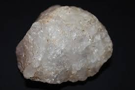
Quartz Crystal Overview and Geology
Quartz (SiO₂) makes up roughly 12% of Earth's crust by volume, making it the second most abundant mineral after feldspar. But there is a massive difference between "quartz exists here" and "you can dig displayable crystals here." The mineral forms in nearly every geological environment — igneous, metamorphic, and sedimentary — yet well-terminated crystals with collectible quality come from a handful of very specific geological settings.
The crystal structure is hexagonal (technically trigonal, a subdivision of the hexagonal system). In the field, that means six-sided prisms capped by six-faced terminations. Quartz grows in open cavities — vugs in granite, pockets in pegmatites, solution cavities in sedimentary rock, and veins cutting through metamorphic terrain. The chemistry is dead simple (silicon and oxygen), which is exactly why quartz is so widespread: those two elements account for nearly 75% of the crust by weight.
Color varieties are driven by trace elements and irradiation. Clear quartz ("rock crystal") is the purest. Smoky quartz gets its brown-to-black color from natural irradiation of aluminum-substituted silicon sites. Amethyst is iron-bearing quartz that has been irradiated. Rose quartz owes its pink color to microscopic fibrous inclusions of a dumortierite-like mineral. Citrine — the yellow variety — is rare in nature; most commercial citrine is heat-treated amethyst.
For the collector, the key geological environments are: (1) Paleozoic sedimentary sequences where silica-rich fluids migrated into open fractures and cavities, as in the Ouachita Mountains of Arkansas; (2) pegmatite bodies, as found throughout the Appalachians; (3) weathered granite with miarolitic cavities, as in Colorado's Pikes Peak batholith; and (4) carbonate host rocks with solution cavities, as in the Herkimer district of New York.
Top US Locations for Quartz Crystals
1. Mount Ida / Jessieville, Arkansas (Ouachita Mountains)
GPS: 34.5595° N, 93.6350° W (general area — Mount Ida)
Land Status: Mix of private fee-dig operations and Ouachita National Forest. Fee-dig mines are the primary access for collectors. National Forest lands surrounding Mount Ida allow personal-use mineral collecting under the 1872 Mining Law and Forest Service regulations, but most productive ground is privately claimed.
Vehicle: Standard 2WD vehicle to fee-dig sites. Some National Forest roads require high clearance during wet weather.
The Ouachita Mountains are the premier quartz crystal producing area in North America, and it is not close. The geology here is straightforward: Ordovician-age sandstone (the Crystal Mountain Sandstone and associated units) was folded and fractured during the Ouachita orogeny roughly 300 million years ago. Silica-rich hydrothermal fluids migrated through these fractures and precipitated quartz in open pockets. Millions of years of weathering have softened the host rock into red clay, making crystal extraction relatively easy compared to hard-rock mining.
The crystals are typically water-clear to milky white, ranging from thumbnail-sized points to clusters weighing hundreds of pounds. Some pockets produce phantom quartz (growth interruption zones visible inside the crystal), and occasional specimens show chlorite inclusions that give them a green tint. The fee-dig operations — Ron Coleman Mining, Wegner Crystal Mines, Sweet Surrender Crystal Mine, and several others — charge a daily fee and let you keep everything you find. Some sites provide heavy equipment (backhoes) to open new ground; others are hand-tool only.
This is about as beginner-friendly as crystal collecting gets. The clay matrix is soft, the crystals are abundant, and the mines provide basic instruction. Bring a garden trowel, screwdrivers, a bucket, and water for washing specimens. A screen or sieve helps separate small crystals from the clay.
2. Herkimer County, New York (Herkimer Diamonds)
GPS: 43.0100° N, 74.9800° W (Middleville area)
Land Status: Private fee-dig operations. No public collecting sites for Herkimer diamonds — all productive ground is privately owned.
Vehicle: Standard 2WD to all fee-dig sites.
Herkimer "diamonds" are doubly terminated quartz crystals with exceptional clarity — they are not actual diamonds, but the name stuck because early settlers thought they looked like cut gemstones. These crystals formed roughly 500 million years ago (Cambrian period) in vugs within the Little Falls Dolostone, a magnesium-rich carbonate rock. The vugs are small solution cavities lined with drusy quartz, and the Herkimer crystals grew freely within these pockets, which is why they developed terminations on both ends.
The two main fee-dig operations are Herkimer Diamond Mines and Ace of Diamonds Mine, both near Middleville. The work here is harder than Arkansas — you are breaking solid dolomite with hammers, chisels, and occasionally sledgehammers to open crystal pockets. Safety glasses are mandatory. When you crack into a pocket, crystals may be loose in clay fill or attached to the pocket walls. Sizes range from rice-grain to fist-sized, though anything over two inches is uncommon.
The best specimens are water-clear with no inclusions, but some contain black hydrocarbon inclusions (anthraxolite) or fluid-filled enhydro cavities. These inclusion specimens are collectible in their own right. Bring a rock hammer, cold chisels, safety glasses, pry bars, and plenty of patience — this is genuinely physical work.
3. Crystal Peak / Lake George, Colorado (Teller County)
GPS: 38.9260° N, 105.3050° W (Crystal Peak area)
Land Status: Mix of private mining claims (some offer fee collecting) and Pike National Forest. The Forest Service allows personal-use mineral collecting on unclaimed National Forest land — check with the Pikes Peak Ranger District (719-636-1602) for current claim maps.
Vehicle: High-clearance 4WD recommended. Forest roads in this area are rough and may be impassable when wet or snow-covered. Seasonal access only (roughly May through October).
Crystal Peak is the best-known smoky quartz and amazonite locality in the United States. The geology is the Pikes Peak Granite, a 1.08-billion-year-old A-type granite (anorogenic — meaning it formed from magma unrelated to plate collision). This granite contains miarolitic cavities — gas pockets that formed as the magma cooled and volatiles concentrated. Quartz, amazonite (green microcline feldspar), and occasionally topaz crystallized in these cavities.
The smoky quartz here ranges from light amber to almost black. Crystals can be enormous — cabinet-sized specimens weighing 50+ pounds come out of this area. The amazonite is what draws many collectors, but the smoky quartz is equally impressive. Several private claims offer fee digging or guided collecting experiences. On unclaimed Forest Service land, you are permitted to collect reasonable quantities for personal use using hand tools only.
Expect to dig. The best specimens are found by excavating into decomposed granite (grus) and following pegmatitic zones until you hit a pocket. This is not surface collecting — it is systematic prospecting.
4. Spruce Pine Mining District, North Carolina (Mitchell County)
GPS: 35.9150° N, 82.0650° W (Spruce Pine area)
Land Status: Mix of active industrial mines (restricted), private fee-dig operations, and Pisgah National Forest. Fee-dig mines are the best option for collectors.
Vehicle: Standard 2WD to fee-dig sites. Some National Forest roads require high clearance.
The Spruce Pine district sits in the heart of the Appalachian pegmatite belt, a zone of lithium-cesium-tantalum (LCT) pegmatites that stretches from Georgia to Maine. These pegmatites intruded Precambrian gneiss roughly 380 million years ago and contain large quartz crystals along with feldspar, mica, beryl, and garnet. The industrial mines here extract high-purity quartz and feldspar for glass and ceramics manufacturing — they are not open to collectors.
For rockhounds, the Emerald Hollow Mine in Hiddenite (Alexander County, about an hour southwest) and several smaller fee-dig operations in the Spruce Pine area provide access. You can find clear quartz, smoky quartz, and occasionally rutilated quartz (quartz with needle-like inclusions of rutile). The Blue Ridge Parkway corridor from Spruce Pine south to Brevard passes through terrain with pegmatite exposures — road cuts and creek beds on National Forest land are worth checking.
5. Diamond Point, Arizona (near Payson, Gila County)
GPS: 34.3150° N, 111.1700° W (general area)
Land Status: Tonto National Forest. Personal-use mineral collecting is permitted under Forest Service regulations. Some adjacent private land is posted — respect boundaries.
Vehicle: High-clearance 4WD required. The access road is rough and rocky.
Diamond Point produces small, clear, doubly terminated quartz crystals similar to Herkimer diamonds, though they tend to be smaller (most under 1 cm). The crystals occur in clay-filled seams within a rhyolite unit of Tertiary age. Surface prospecting along eroded hillsides and dry washes turns up loose crystals. You can also dig into the clay seams to extract crystals in matrix. The crystals are transparent and well-formed, making them excellent micromount or thumbnail specimens.
The drive in is the main challenge — a 4WD with decent clearance is not optional. Bring a garden trowel, sieve, and water. The clay deposits are dry in summer and require careful screening to separate crystals from debris.
6. Fairy Stone State Park Area, Virginia (Patrick County)
GPS: 36.7910° N, 80.1070° W (Fairy Stone State Park)
Land Status: Virginia State Park. Collecting of "fairy stones" (staurolite twin crystals) is permitted in the designated collecting area within the park. Quartz crystals occur in the surrounding Blue Ridge terrain on private and National Forest land.
Vehicle: Standard 2WD to the state park and most surrounding areas.
While Fairy Stone State Park is best known for staurolite cross-shaped twins, the region's schist and gneiss terrain hosts quartz veins that produce collectible crystals. Road cuts along the Blue Ridge Parkway and stream gravels draining the metamorphic complex yield smoky and clear quartz. The collecting here is more casual — you are scanning road cuts and creek beds rather than operating a dig site.
Quartz Crystal Specimen Types
| Variety | Color | Key Locations | Typical Size Range | Collector Value |
|---|---|---|---|---|
| Clear quartz (rock crystal) | Colorless, transparent | AR, NY (Herkimer), AZ | 1 cm to 30+ cm | $2–$500+ depending on clarity and size |
| Smoky quartz | Light brown to nearly black | CO (Crystal Peak), NC, NH | 5 cm to 50+ cm | $10–$1,000+ for large cabinet pieces |
| Amethyst | Purple (pale to deep) | AZ (Four Peaks), SC, GA, ME | 1 cm to 15 cm | $5–$300+ depending on color saturation |
| Rose quartz | Pink (usually massive, not crystallized) | SD (Black Hills), ME, NC | Massive chunks to rare crystals | $1–$50 massive; crystallized very rare |
| Rutilated quartz | Clear with golden rutile needles | NC, GA, VA | 2 cm to 10 cm | $10–$200+ for well-included specimens |
| Phantom quartz | Clear with ghostly internal crystal outlines | AR, CO, NC | 3 cm to 20 cm | $15–$400+ for distinct phantoms |
| Herkimer diamonds | Water-clear, doubly terminated | NY (Herkimer County) | 0.5 cm to 8 cm | $5–$500+ for large clear specimens |
Field Identification: Quartz vs. Look-Alikes
| Property | Quartz | Calcite | Topaz | Feldspar |
|---|---|---|---|---|
| Hardness (Mohs) | 7 | 3 | 8 | 6–6.5 |
| Crystal Habit | Six-sided prisms with pointed terminations | Rhombohedral or scalenohedral | Eight-sided prisms, orthorhombic | Blocky, tabular, two cleavage directions |
| Cleavage | None (conchoidal fracture) | Perfect rhombohedral (3 directions) | Perfect basal cleavage (1 direction) | Two directions at ~90° |
| Acid Test | No reaction | Fizzes vigorously in dilute HCl | No reaction | No reaction |
| Streak | White | White | White | White |
| Luster | Vitreous (glassy) | Vitreous to pearly | Vitreous | Vitreous to pearly on cleavage |
The most common field confusion is quartz vs. calcite. The scratch test settles it instantly: quartz scratches glass; calcite does not. If you carry a small bottle of dilute hydrochloric acid (or white vinegar in a pinch), calcite fizzes and quartz does not react. Cleavage is another fast check — break a piece and look at the fracture surface. Quartz breaks with smooth, curved (conchoidal) surfaces. Calcite breaks along flat cleavage planes.
Topaz co-occurs with quartz at Crystal Peak, Colorado. Topaz is harder (8 vs. 7) and has a single perfect basal cleavage — if you can cleave a flat sheet off the crystal, it is topaz, not quartz. Feldspar (especially orthoclase and microcline) occurs in pegmatites alongside quartz. Feldspar has two cleavage directions that meet at roughly 90 degrees, giving broken surfaces a blocky, stepped appearance that quartz never shows.
Tools for Quartz Crystal Collecting
- Rock hammer (2–3 lb) and cold chisels: Essential for hard-rock extraction at Herkimer and Crystal Peak. In Arkansas, a lighter garden trowel works for clay deposits.
- Safety glasses: Non-negotiable. Quartz produces razor-sharp conchoidal fragments when struck. Flying shards can cause serious eye injury.
- Screwdrivers and dental picks: For prying crystals out of clay pockets without breaking terminations. A set of flat-head screwdrivers in multiple sizes is more useful than you expect.
- Bucket, water, and sieve/screen: Washing specimens in the field reveals quality immediately. A 1/4-inch mesh screen helps recover small crystals from Arkansas clay.
- Newspaper and bubble wrap: Crystal points are fragile. Wrap each specimen individually before placing in a bucket or pack. Crystals banging together in a bucket is how you turn a good day into a pile of damaged specimens.
- Pry bar (18–24 inch): Useful at Herkimer for levering apart dolomite layers to expose crystal pockets.
- Hand lens (10x loupe): For evaluating clarity, inclusions, and phantom features in the field.
Legal Considerations
Fee-dig sites: You pay a fee and keep what you find. Rules vary by operation — some allow power tools, some do not. Ask before bringing equipment.
National Forest land: The Forest Service generally permits personal-use mineral collecting with hand tools on unclaimed land. You cannot use mechanized equipment, explosives, or disturb more than a small area. Check with the local Ranger District — regulations and claim status change.
BLM land: Similar rules to Forest Service for casual collecting. Reasonable quantities for personal use, hand tools only. No commercial collecting without a permit.
State parks: Varies wildly by state. Some (like Flint Ridge in Ohio) have designated collecting areas. Others prohibit all collecting. Always check specific park regulations.
Private land: Get written permission. Period. Trespassing on posted land or active mining claims is illegal and gives all rockhounds a bad reputation.
Explore the Interactive Quartz Map
Use our interactive quartz location map to find collecting sites near you with GPS coordinates, land status, and access information. Also check our quartz crystals map for crystal-specific locations across all 50 states.